by Josh Jackson
If I were to tell you I was going to visit a “wild and scenic river,” what kind of images would that conjure up for you? Perhaps a raging rapids of white water careening through large boulders? Or how about a meandering tributary with deep pools and a gentle current, running in the shadow of an evergreen forest? At least for me, these were the visions I had for wild and scenic – something akin to the Kings flowing through the Sequoia’s or the clear waters of the Smith wandering through towering Redwoods. My grandiose idealism defined wild as untamed and scenic as the kind of picturesque beauty that is universally praised and accepted. But I had been learning, albeit slowly, to find beauty in unexpected places.
Over the past four years, in response to threats facing our most vulnerable and least visited public lands, I have been working on a book project to document and explore each and every landscape in California managed by the Bureau of Land Management (BLM). This has included researching, camping and walking hundreds of miles among the staggering fifteen million acres of BLM land in California. Part of this vast acreage is 124.2 miles of federally designated wild and scenic rivers. It wasn’t until my research deepened that I discovered that the second longest stretch of these rivers was in the middle of the Mojave Desert. The notion of a wild and scenic river in the parched southwest certainly challenged my preconceived ideals. I decided I needed to see it for myself.
Thanks to a tip on the BLM website about easy access and hiking trails, I left my home in Los Angeles and headed two hundred and forty miles northeast, toward some BLM land just south of a famous valley named Death and a mountain range named Funeral. It was here, in one of the hottest places on the planet, where I’d find the Amargosa River.
It’s January, early afternoon. I am standing in the back parking lot at the China Ranch Date Farm, where accessing the river has never been easier thanks to a collaborative effort between the BLM, Nature Conservancy, Amargosa Conservancy and Brian Brown, who has privately owned the China Ranch Date Farm since 1970. Since the conservation easement was established, numerous trails have been built throughout the Amargosa Canyon, along with information boards, picnic tables and a vault toilet.
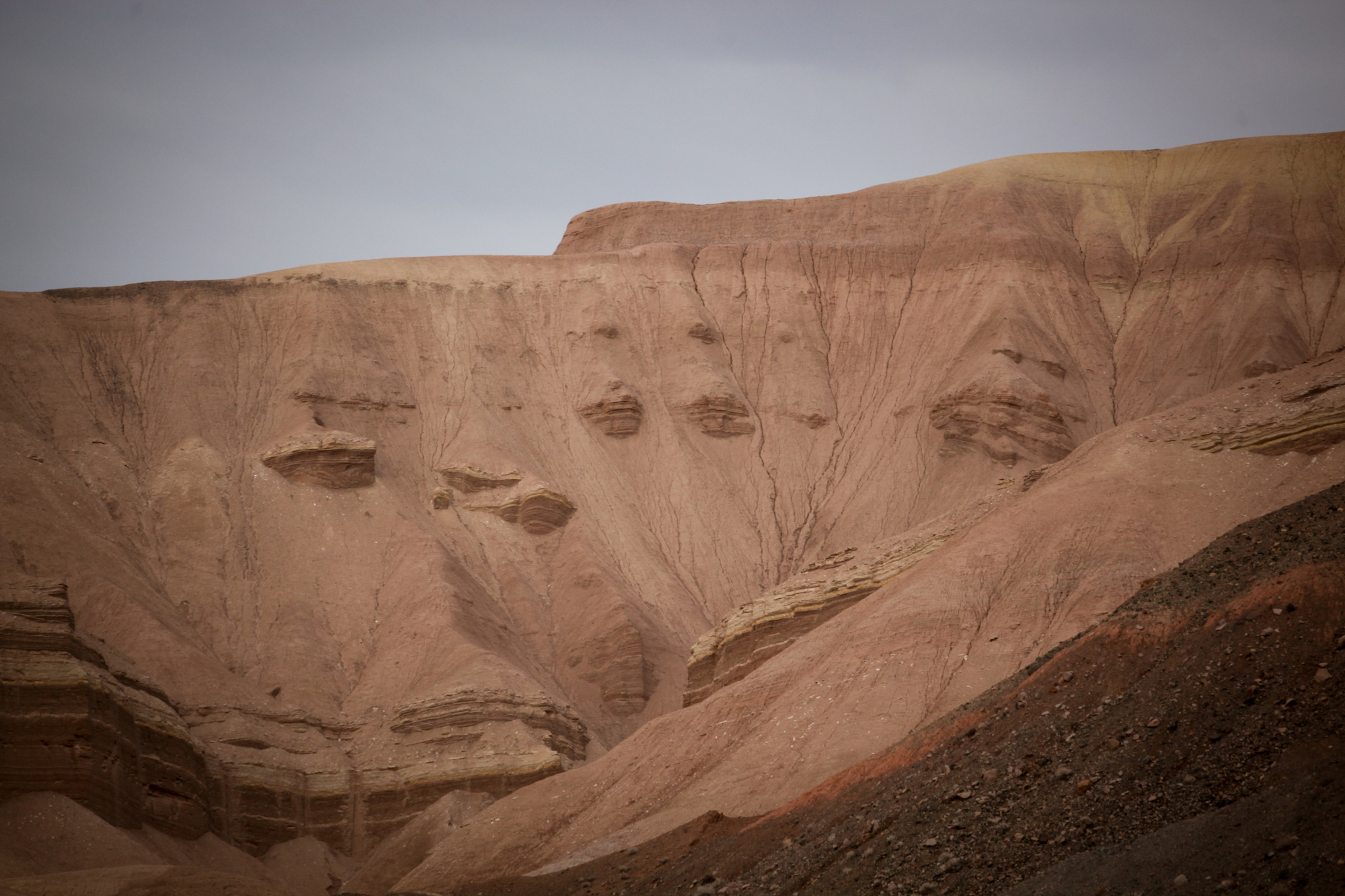
photo by Josh Jackson
While studying the trail maps, I scarf down an apple and throw various items of necessity into my backpack. My hip pack contains the usual for my long walks on BLM land: phone, notepad, pencil and a wilderness whistle for safety in case things go awry, which out here probably means falling off a cliff more than, say, meeting a mountain lion.
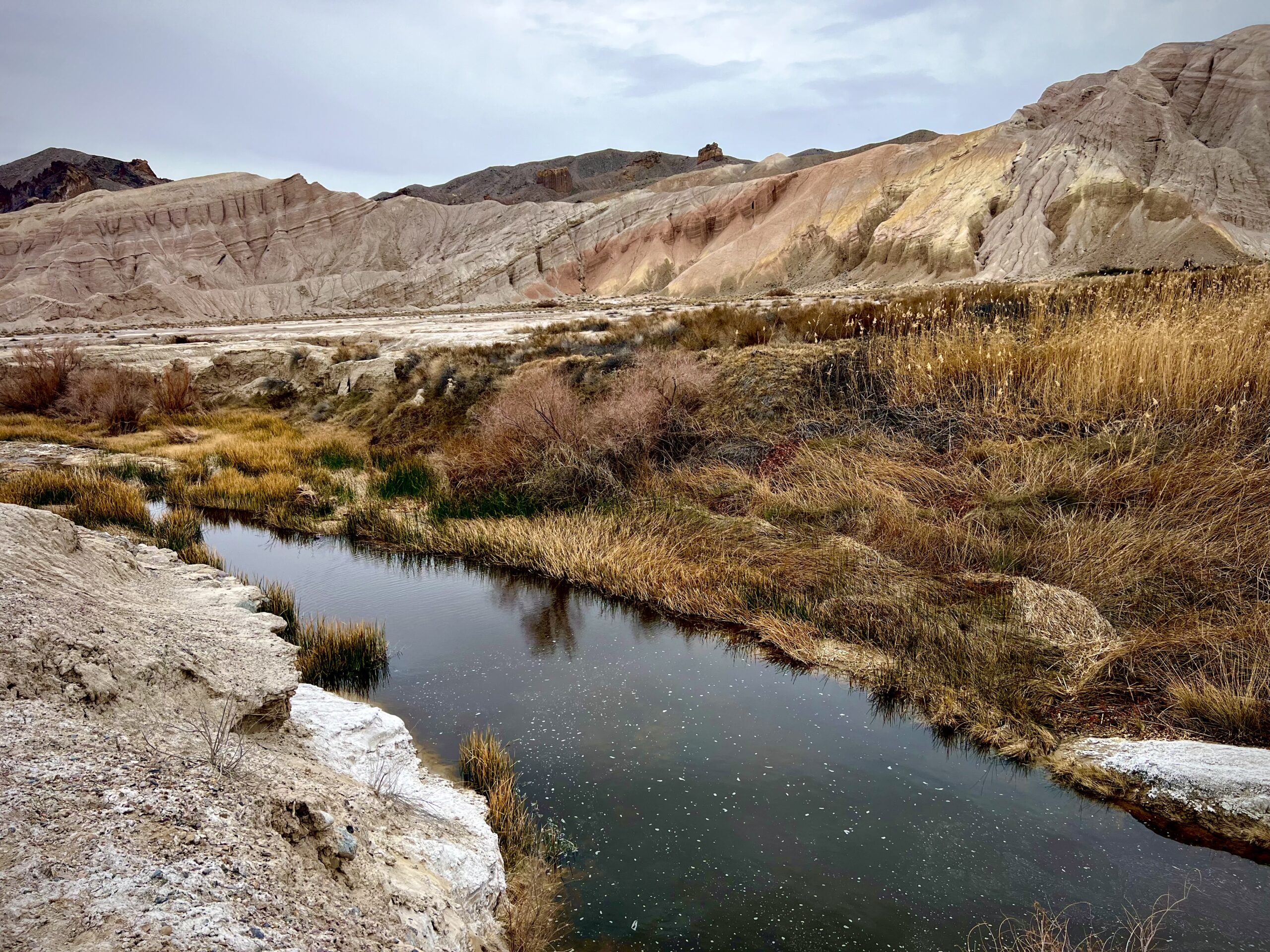
I head out along a developed trail that winds through a thick maze of Mesquite and Willow trees, following the path of Willow Creek, which carries a small but steady flow of water. As the trail forks away from the creek, and the canopy slowly fades away, the views start opening up to reveal the canyon in more detail. Clouds hang over the scene like eggshell colored bed sheets, and shades of dusk have already begun settling over the landscape.
This is the native homeland of the Timbisha Shoshone, a Numic-speaking peoples that have inhabited this place for at least a thousand years and still live here today. The name ‘Timbisha’ comes from the red ochre found in the mountains near Death Valley and is used as a paint for protection, healing, and spiritual strength. They call their ancestral homeland Tüpippüh, which encompasses the canyons, mountains, valleys, dunes and waterways throughout the Amargosa Basin. In a moving letter to congress, tribal activist Pauline Estevez writes, “The Timbisha people have lived in our Homeland forever and we will live here forever. We were taught that we don’t end. We are part of our Homeland and it is part of us. We are people of the land.”
The recent rains and overcast sky create striking colors on the tallest mountain that looms over the canyon, giving it a monolithic appearance as it towers approximately seven hundred feet above the canyon floor. I can’t take my eyes off it. It’s a rainbow of diverse sedimentary rock from top to bottom, the fractures, rifts and cracks running horizontally like lines on a topography map. From the faded black rock beds all the way up to the top of the ridge is a patchy concoction of colors; chocolate brown, crimson, burnt orange, hazel and bands of white and pink.
Rainbow Mountain, near China Ranch Date Farm (photo by Josh Jackson)
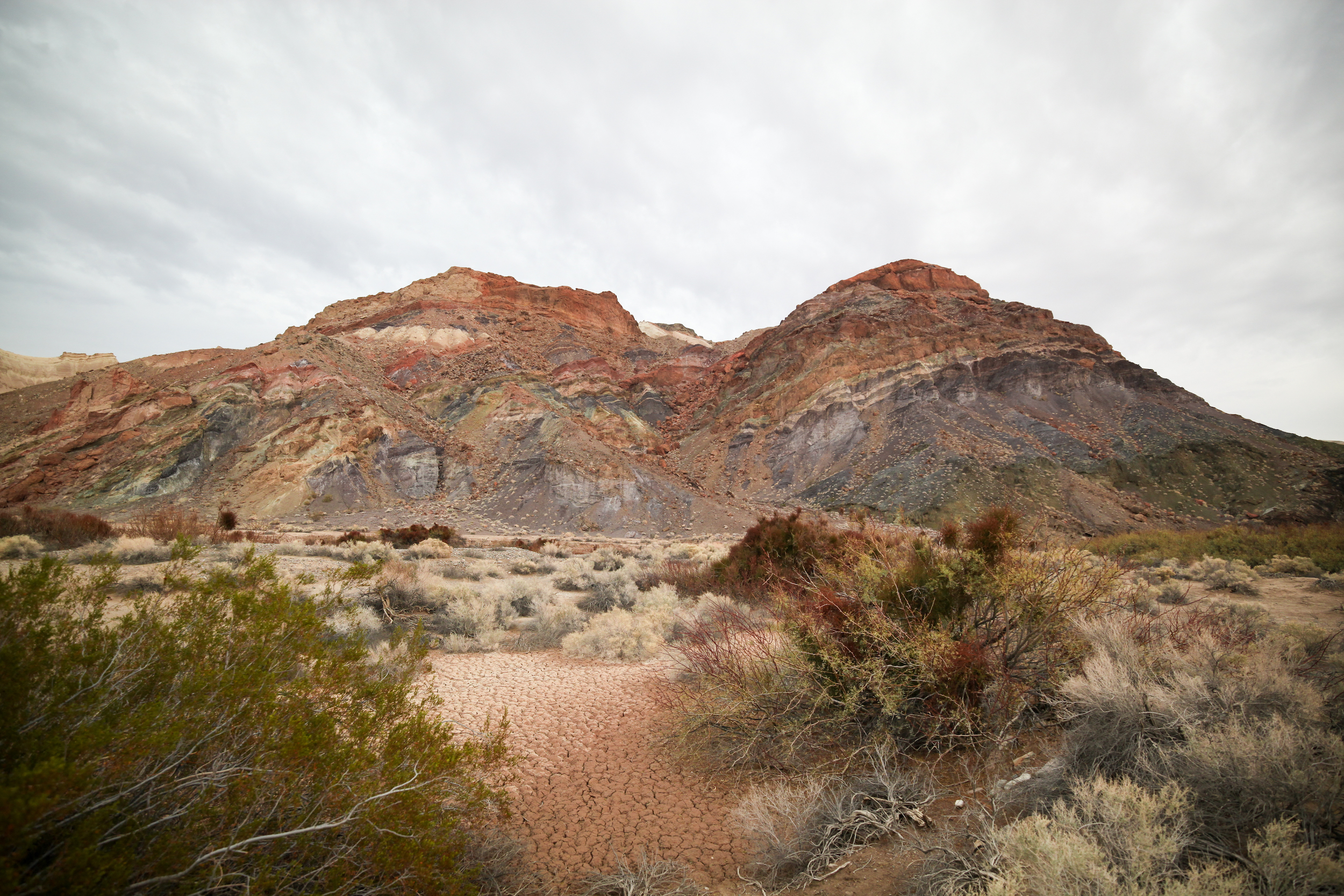
Creosote bushes thrive in scattered clusters alongside other low-growing shrubs like Seepweed, Longleaf jointfir, and White bursage. The guileful Desert Mistletoe, also known as the ‘tree thief,’ hangs in dense clusters, primarily on the unruly branches of the thorny Mesquite. On first glance, the Mistletoe seems to be using the branches of the Mesquite to climb closer to the sun, and doing it so thoroughly that it is hard to differentiate between which branch is from which tree. The reality of the matter is even more mysterious, as the seeds from the pink berries of the Mistletoe actually germinate on the very bark of the host tree, in the microscopic spaces between cells, withdrawing water and nutrients from the very tree it has latched onto.
As I edge closer to the lookout above the river, where the canyon makes a wide turn from the southeast to the southwest, I am suddenly stopped in my tracks by a sight off the trail. A lone coyote is looking up at me, perfectly still. I pause, lifting my binoculars slowly until our eyes meet, its gaze intently observing my every movement. I stare into its eyes, a hypnotizing blend of yellow and brown, and my heart rate starts picking up even though I know it’s not a threat. After a few moments, it turns and trots out of sight.
Standing at the canyon’s lookout, I begin taking in all its majesty. It is immense, running hundreds of feet wide in some places, with vertical walls ten to twenty feet high on both sides, carved out by a millennia of flash floods. The sun begins peaking through in fits and starts, adding vividness to the scene. And then I finally lay eyes on what many consider the “crown jewel” of the Mojave. The unassuming Amargosa River winds its way through the heart of the canyon, nourishing the soil that supports a rich tapestry of plant life. This peaceful waterway serves as a gathering place for wildlife and a haven of shade for various bird species. Cattails are stacked up like bamboo and clumps of salt grasses run from the river up to the base of the canyon walls, intermingled with the invasive tamarisk tree. Between the symphony of color on the looming mountain and the green, mustard and auburn colors that are showcased in the flora along the waters edge, there is enough vibrancy here to make a watercolor dreamscape.
The Amargosa may not be on mainstream maps or written about in guidebooks. And when compared to the more famous California wild and scenic rivers, it may not make as much noise. But out here in the parched desert, where its very existence feels like a miracle, the improbable Amargosa is full of pristine beauty and profound meaning.
I start walking back as the disappearing sun is casting it’s last light on the highest peaks that surround me. I point my camera to mountain tops turned copper and sandy ridges turned golden, and to the sullen sky rapidly morphing from dark gray to deep blue. I arrive back at my van sitting alone in an empty parking lot. Darkness completes its takeover as I drive away, up through a steep canyon and into the night, looking for a place to camp.
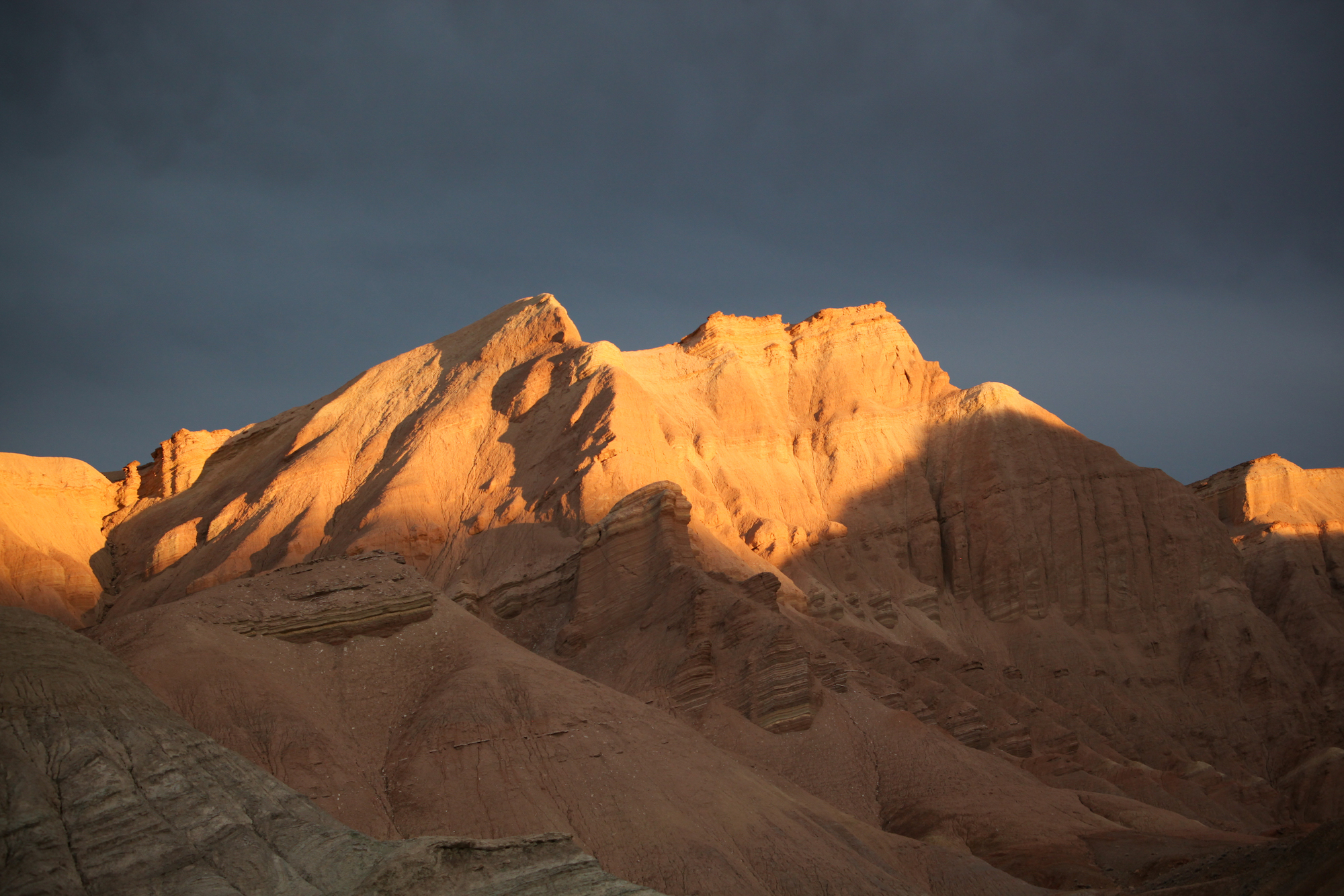
photo by Josh Jackson